Nar Phu Valley Trek Day by Day: What Each Day on the Trail Actually Looks Like
Forget the generic itineraries. Here is what each day of the Nar Phu Valley trek actually feels like — the early mornings, the hard climbs, the moments that catch you off guard, and the practical details that matter when you are out there.
I have led groups through Nar Phu Valley more times than I can count, and every trek is different. The weather changes, the trail conditions shift, and every group has its own rhythm. But the bones of the journey stay the same, and after years of guiding this route, I can tell you what each day is really going to feel like — not just the distances and elevations, but the parts that the standard itineraries leave out.
This is a 12-day breakdown of the most common Nar Phu Valley trek itinerary, from Kathmandu and back. Some agencies stretch it to 14 or 15 days. Some compress it to 10. I think 12 is the sweet spot — enough time to acclimatize properly without rushing, but not so stretched out that you are filling days with unnecessary stops.
Day 1: Kathmandu to Dharapani (1,860m)
Drive time: 9-10 hours by jeep What it is really like: Long. Really long.
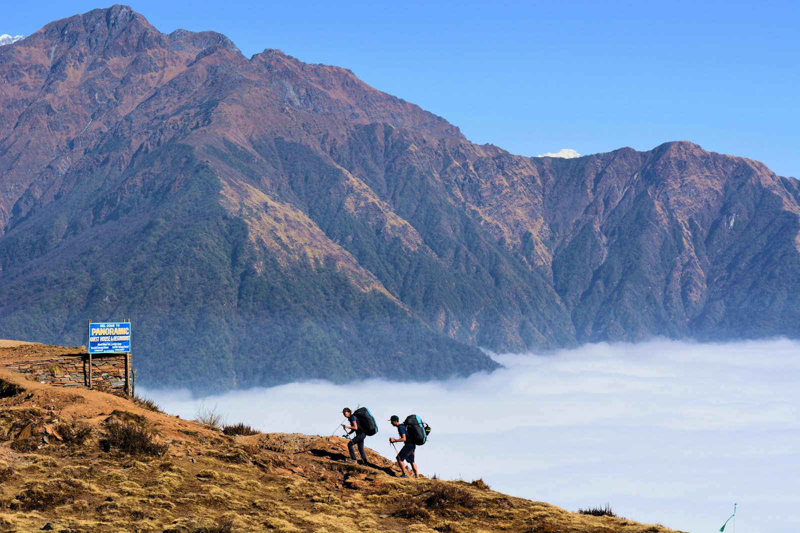
You leave Kathmandu early, ideally by 6 AM, before the traffic turns the ring road into a parking lot. The drive follows the Prithvi Highway west to Dumre, then turns north along the Marsyangdi River toward Besisahar and beyond.
The road from Besisahar to Dharapani is where your patience gets tested. This is not a highway — it is a rough, unpaved track carved into the side of the Marsyangdi gorge. Dust in the dry season, mud in the wet season, and bumpy all year round. Your jeep will grind through river crossings, squeeze past oncoming vehicles on single-lane stretches, and bounce over rocks that would destroy a regular car.
But the scenery is stunning. The Marsyangdi Valley is deep and green, with terraced rice fields climbing the hillsides and waterfalls cascading from impossible heights. By the time you reach Dharapani, you are properly in the mountains.
Where you sleep: Basic teahouse in Dharapani. Hot shower probably available. Simple but comfortable rooms. Order dinner immediately — the kitchen is small and cooks for everyone in order of arrival.
What I tell my groups: "Eat well tonight. The food gets simpler from here."
Day 2: Dharapani to Koto (2,600m)
Walking time: 6-7 hours, approximately 13-14 km Elevation gain: 740m What it is really like: A proper introduction to trekking.
This is your first real walking day, and it is a good one. The trail follows the Marsyangdi River upstream through increasingly beautiful forest. You pass through several small villages — Bagarchap, Danaque, Timang — each one quieter and more traditional than the last.
The views of Mt. Manaslu (8,163m) open up as you gain elevation. If the weather is clear, and in autumn it usually is, the mountain dominates the skyline to the east. Take your time at the viewpoints. This is some of the best Manaslu viewing outside the Manaslu Circuit itself.
Koto is the gateway to the Nar Phu Valley. There is a police checkpoint here where your restricted area permit will be inspected for the first time. Make sure your guide has all your documents ready — the officers are thorough.
Where you sleep: Teahouse in Koto. Reasonable comfort. This is the last point where the Nar Phu trail and the Annapurna Circuit share the same path.
What I tell my groups: "Tomorrow we leave the main trail. Everything changes."
Day 3: Koto to Meta (3,500m)
Walking time: 8-9 hours Elevation gain: 900m What it is really like: The day the trek becomes real.
This is one of the longer and more demanding days, and also one of the most dramatic. You cross the Marsyangdi River on a suspension bridge and immediately enter a different world. The trail plunges into a narrow gorge along the Nar Khola, winding through dense pine and rhododendron forest.
The path here is carved into cliffside in places, with the river roaring far below. It is not dangerous if you are careful, but it requires attention. There are steep sections, some scrambling over rocks, and a few exposed traverses that give pause to people uncomfortable with heights.
As you gain elevation, the forest begins to thin and the landscape transitions from lush and green to dry and open. By the time you reach Meta, the change is startling — you have walked from the monsoon zone into the rain shadow, and the terrain looks more like Tibet than Nepal. Golden hillsides, sparse vegetation, wide valley views.
Meta is a small collection of stone buildings and a few teahouses. It sits at the boundary between two worlds, and it feels like it.
Where you sleep: Basic teahouse in Meta. Rooms are simple. Shared toilet. No hot shower, though some teahouses can heat water for a bucket wash. The communal dining room with its wood stove is where everyone gathers in the evening.
What I tell my groups: "You just walked into one of the most restricted valleys in Nepal. Less than 400 people a year see what you are about to see."
Day 4: Acclimatization Day in Meta (3,500m)
What it is really like: Essential and surprisingly enjoyable.
I know some trekkers grumble about rest days. They feel strong, the weather is good, and they want to keep moving. But Meta at 3,500 meters is exactly where altitude sickness begins to become a real risk if you rush. We stay.
The day is not wasted. There are excellent short hikes around Meta for acclimatization — walking up to higher viewpoints and then returning to sleep at 3,500m follows the "climb high, sleep low" principle that keeps altitude sickness at bay.
The views from the ridges above Meta are extraordinary. You can see down the Nar Khola gorge toward the green world you left behind, and up the valley toward the barren high country ahead. If you are lucky, you will spot blue sheep (bharal) on the cliffs across the valley — they are more common here than most people expect.
This is also a good day to talk with your guide about the days ahead. The route from Meta to Phu involves significant elevation gain, and understanding what to expect mentally prepares you better than any amount of physical training.
What I tell my groups: "Your body needs this day even if your mind does not. Trust the process."
Day 5: Meta to Phu (4,250m)
Walking time: 8-9 hours Elevation gain: 750m What it is really like: Long, stunning, and the first time you feel real altitude.
This is the day you enter the deep Nar Phu Valley. The trail continues up the Phu Khola, passing through a landscape that becomes increasingly arid and otherworldly. You walk through narrow canyons with walls of red, gold, and grey sedimentary rock that look like they belong in Utah rather than Nepal.
You pass through two small settlements along the way: Chyaku and Kyang. Chyaku has a beautiful collection of mani walls and chortens. Kyang is more atmospheric — a partly abandoned village that was once a base for Khampa Tibetan guerrilla fighters in the 1960s. Your guide will probably tell you the story. It adds an unexpected layer to the trek.
The final approach to Phu involves crossing several suspension bridges and climbing a steep trail to where the village sits perched on a rocky spur above the river confluence. When you first see Phu — medieval stone buildings clinging to a cliff face, prayer flags streaming in the wind, the massive bulk of Himlung Himal rising behind — it is genuinely one of those moments that stops you in your tracks.
You will feel the altitude today. At 4,250 meters, breathing is noticeably harder, and you may have a mild headache by evening. This is normal. Drink at least three liters of water throughout the day.
Where you sleep: Teahouse in Phu. Very basic. Cold rooms. The dining room stove is your best friend.
What I tell my groups: "Welcome to one of the most remote villages in Nepal. There are roughly 200 people who live here. You are now one of them for a night."
Day 6: Exploration Day in Phu (4,250m)
What it is really like: Magical, if you let it be.
This is the day many trekkers remember most vividly. You have a full day to explore Phu village and its surroundings, and there is more here than you would expect.
Tashi Lhakhang Monastery is the highlight. Over 700 years old, it is recognized as one of the 108 great Buddhist monasteries worldwide. The resident monks may allow you inside to see the ancient murals, butter lamps, and prayer halls. If morning prayers are happening when you visit, sit quietly and just absorb it. The deep chanting, the smell of butter lamps and juniper incense, the golden light on centuries-old artwork — it is an experience that transcends trekking.
For the more energetic, an optional hike toward Himlung Base Camp (about 4,900m) offers spectacular mountain views and excellent acclimatization. The round trip takes 5-7 hours. Do not push for the base camp itself unless you are feeling strong — even reaching the high meadows above Phu gives you incredible views of Himlung Himal (7,126m).
Wander through the village in the afternoon. Watch women spinning wool on hand spindles. See kids playing on the stone-paved lanes. Look at the flat rooftops where grain and yak meat dry in the sun. Phu feels like stepping into a world that exists outside of time.
What I tell my groups: "Take your time today. You did not come all this way to rush."
Day 7: Phu to Nar (4,130m)
Walking time: 8-9 hours Elevation gain/loss: Some descent, some ascent (net slight descent) What it is really like: A tough day between two remarkable places.
The trail from Phu to Nar is one of the more demanding sections of the trek. You retrace part of the trail toward Chyaku, then branch off on the path toward Nar. The route crosses several suspension bridges and passes through a landscape of Buddhist stupas, mani walls, and prayer flag-draped mountain passes.
There is a significant climb involved — you drop down from Phu and then have to gain elevation again to reach Nar. The middle section involves some steep, rocky terrain that can be tiring after a week of trekking.
But the reward is Nar. When the trail opens into the vast natural amphitheater where Nar village sits — golden rock walls curving around the settlement like cupped hands, stone houses blending into the cliff face, prayer flags catching the high-altitude light — the tiredness evaporates. Nar is, in my opinion, the single most beautiful settlement in the Himalayas.
Where you sleep: Teahouse in Nar. Similar standard to Phu — basic rooms, communal dining, stunning setting.
What I tell my groups: "Look up when you enter the amphitheater. Every person I have brought here has said the same thing: they were not prepared for how beautiful it would be."
Day 8: Exploration Day in Nar (4,130m)
What it is really like: The calm before the storm.
Tomorrow you cross Kang La Pass. Today you rest, explore, and prepare.
Nar village rewards slow exploration. The monastery (Nar Gumba) is the spiritual heart of the village, with beautiful frescoes, prayer wheels, and butter lamps. The village layout itself tells a story — stone houses with thick walls and flat roofs designed for an extreme climate, communal grain stores that speak of a cooperative society, and mani walls at every entrance inscribed with sacred mantras.
Hike to the viewpoint above the village (about 4,400m) for panoramic views of the amphitheater, the surrounding peaks, and the Kang La route you will take tomorrow. This is excellent "climb high, sleep low" acclimatization.
Keep an eye on the cliffs around the amphitheater. Blue sheep are frequently seen here in herds of 20 or more, picking their way across rock faces that look vertical. Where there are blue sheep, there may be snow leopards — though seeing one requires extraordinary luck.
In the evening, go over the Kang La plan with your guide. Early start. Warm layers. Trekking poles essential. Snacks and water accessible. Camera charged.
What I tell my groups: "Get everything ready tonight. We leave at 4 AM tomorrow, and you do not want to be packing in the dark."
Day 9: Nar to Ngawal via Kang La Pass (5,320m pass, ending at 3,650m)
Walking time: 10-11 hours Elevation gain: 1,190m up, then 1,670m down What it is really like: The hardest and most rewarding day of the trek.
This is the big one. You wake at 3:30 AM, eat a quick breakfast in the dark, and start walking by 4:00 or 4:15. Headlamps on, layers on, trekking poles ready.
The trail climbs steadily from Nar up through increasingly barren terrain. The first hour or two is in darkness — you follow your headlamp beam and the boots of the person ahead. As dawn breaks, you realize you are in a high, wide valley of rock and ice, with peaks glowing pink on every horizon.
The final push to the 5,320-meter pass is steep and slow. At this altitude, every step requires deliberate effort. Your breathing is loud. Your legs feel heavy. The air has about half the oxygen content of sea level. This is where your acclimatization days pay off — or do not.
But the pass itself. I have stood on Kang La maybe forty times, and it still gets me. The view is 360 degrees of Himalayan grandeur. Annapurna II, III, and IV. Gangapurna. Tilicho Peak. Pisang Peak. The Chulu range. Himlung Himal behind you. Prayer flags snap violently in the wind. The sky is a shade of blue that you do not see at lower altitudes.
Do not linger too long — the wind chill at the pass is brutal and the descent is long. The trail down from Kang La toward Ngawal is steep and demanding on the knees. Trekking poles are not optional here. The terrain is loose rock and scree for the first section, then gradually improves as you lose altitude.
By the time you reach Ngawal, you will have walked for 10 or 11 hours and descended almost 1,700 meters from the pass. You will be exhausted. But you will also be carrying one of the great mountain experiences of your life.
Where you sleep: Teahouse in Ngawal. Noticeably more comfortable than Nar or Phu — you are back on the Annapurna Circuit now, where infrastructure is more developed.
What I tell my groups: "You just crossed one of the highest trekking passes in Nepal. That deserves a second cup of tea."
Day 10: Ngawal to Manang (3,519m)
Walking time: 5-6 hours Elevation loss: 130m (relatively flat) What it is really like: Easy and beautiful. A victory lap.
After the intensity of Kang La, this is a gentle day. The trail follows the upper Marsyangdi Valley toward Manang, passing through the villages of Braga and offering continuous views of the Annapurna range.
Stop at Braga for its ancient monastery — one of the oldest in the Manang district, with 500-year-old murals and an atmosphere of deep stillness.
Manang itself is a proper town by Nar Phu standards. There are bakeries selling apple pie and cinnamon rolls. There are shops where you can replace broken gear. There is (slow, expensive) Wi-Fi. After a week in one of the most remote valleys in Nepal, Manang feels almost metropolitan.
This is also a natural decision point: some trekkers continue on the Annapurna Circuit from here, crossing Thorong La Pass (5,416m) to Muktinath. Others head to Tilicho Lake. Most Nar Phu trekkers, though, begin the journey back to Kathmandu from Manang.
Where you sleep: Comfortable teahouse or guesthouse in Manang. Hot showers. Western-style food options. Relative luxury.
What I tell my groups: "You have earned that apple pie."
Day 11: Manang to Besisahar (Drive)
Drive time: 8-10 hours by jeep What it is really like: Bumpy but manageable.
The road from Manang to Besisahar has been improving in recent years, though "improving" is relative. It is still a rough mountain track for much of its length, but jeeps run the route regularly.
The drive retraces the Marsyangdi Valley, passing through all the Annapurna Circuit villages you might otherwise have trekked through — Chame, Bagarchap, Syange, Jagat. You lose elevation steadily, and with it the landscape changes from dry high-altitude terrain back to lush subtropical forest.
Some agencies break this into two days, with an overnight in Chame or Besisahar. I prefer to push through in one day if the road conditions allow — after the intensity of the trek, most people just want to get to a comfortable bed.
What I tell my groups: "One more day of bumpy roads, and then it is over."
Day 12: Besisahar to Kathmandu
Drive time: 6-7 hours What it is really like: The return to civilization.
The road from Besisahar to Kathmandu is paved and, by Nepali standards, comfortable. You rejoin the Prithvi Highway and follow it east through Dumre and Mugling toward the capital.
Arriving in Kathmandu after Nar Phu is always slightly surreal. The noise, the traffic, the crowds, the choices — it all feels amplified after days of stone villages and mountain silence. Most trekkers head straight for Thamel, check into a hotel, and take the longest hot shower of their lives.
Elevation Profile Summary
| Day | Start | End | High Point | Notes | |-----|-------|-----|-----------|-------| | 1 | Kathmandu (1,350m) | Dharapani (1,860m) | - | Drive | | 2 | Dharapani (1,860m) | Koto (2,600m) | 2,600m | First walking day | | 3 | Koto (2,600m) | Meta (3,500m) | 3,500m | Enter restricted area | | 4 | Meta (3,500m) | Meta (3,500m) | ~3,800m | Acclimatization | | 5 | Meta (3,500m) | Phu (4,250m) | 4,250m | Enter deep valley | | 6 | Phu (4,250m) | Phu (4,250m) | ~4,900m | Explore / HBC option | | 7 | Phu (4,250m) | Nar (4,130m) | ~4,300m | Between villages | | 8 | Nar (4,130m) | Nar (4,130m) | ~4,400m | Acclimatization | | 9 | Nar (4,130m) | Ngawal (3,650m) | 5,320m | Kang La Pass | | 10 | Ngawal (3,650m) | Manang (3,519m) | 3,650m | Easy day | | 11-12 | Manang | Kathmandu | - | Drive |
What the Itinerary Does Not Tell You
Numbers on a page do not capture certain things. They do not capture the feeling of walking into Phu village for the first time and realizing you are standing somewhere genuinely untouched by the modern world. They do not capture the 4 AM darkness before Kang La, when your world shrinks to the circle of your headlamp and the crunch of your boots. They do not capture the evening in Nar when the monastery bells ring at sunset and the entire amphitheater turns gold.
These are the things that make Nar Phu different from a gym workout with scenery. The itinerary gets you there. The place does the rest.